Traversing through mountains and hills is a strenuous and sometimes dangerous endeavor. And while trekking up a mountain poses its set of risks, the reward at the end is always worth it.
Most people may not know it, but Bohol is actually a hidden gem when it comes to easily-hiked and traversed hills and mountains. While Bohol is mostly known for its beautiful beaches, it is also home to a good number of trails and peaks that are sure to satisfy the wanderlust of hikers and nature-lovers alike.
So without further adieu, if you fancy spending a few hours of your visit to Bohol for the magnificent views, then this list is a definite addition to your bucket list.
Alicia Panoramic Park/Binabaje Hills
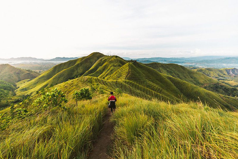
Photo by Jackson Groves via Journey Era
Located in the town of Alicia, Binabaje Hills also known as Alicia Panoramic Park, offers a beautiful sight to behold. Located an hour from the town of Anda, hikers must get a guide from the Municipal Hall, who will drive them to the foothills of Binabaje. It is not advisable that you drive to the foothills on your own as the trail can be muddy, winding, and quite tricky. From there, the hike to the peak will only take about an hour.
The views from Binabaje are best seen at sunrise which means you will have to leave the town of Alicia at dawn, at about 3 or 4 am. The hill is very steep so the drive can be a little dangerous as you will be traveling in the dark, which is why a guide is necessary if you want to get to the peak in one piece.
Bohol Tarsier Trail
As the name has it, this trail will allow you to explore the natural habitat of the Philippine tarsier, the smallest primate in the world. It is a much-traversed trail in the town of Corella, with a pathway that’s filled with forested terrain, wildlife, and of course, the sanctuary of the tarsiers.
A 15-km trail, it has been set up by the Philippine Tarsier Foundation Inc., to enable interested parties to observe these primates in their natural habitat, as well as for educational purposes. The rich flora and fauna that surrounds this trail is filled with many species of trees and animals. Trees and plants along the trail have signages denoting their scientific names and other pertinent information.
The trail ends in Loboc, where hikers can have the option of swimming in Busay Falls or Loboc River.
Can-umantad Trail
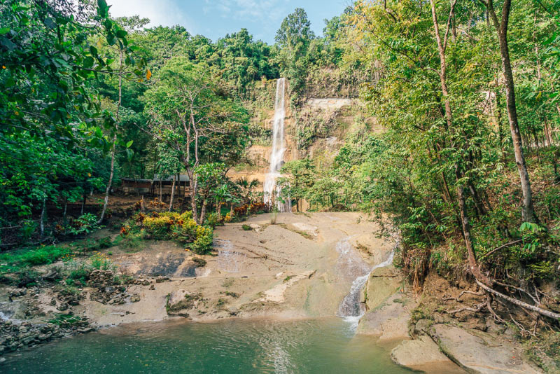
Photo by Jonny Melon
The trail is basically the trek going to the popular Can-umantad Falls. Located in the town of Candijay, which is on the eastern part of the island, the trail boasts of rolling grasslands, steep hills, and of course, the beautiful sight of the Can-umantad Falls in the end of the journey.
Candijay town is about 92.2km from Bohol’s capital city of Tagbilaran, so if you’re planning on doing this trek, you can either rent your own private vehicle or ride a bus going to town, then head to Canawa Spring in Barangay Can-umantad, which is the ideal starting point of the trek. The 10-km trail is strenuous and challenging so having a guide is definitely recommended.
Cambia Route
An extension of the Can-umantad Trail, the Cambia Route is 15 km long and a more challenging trek than the previous. It leads to the village of Biabas in Guindulman, which is home to the Eskaya tribe. Hiring a guide is highly advisable.
The trail also starts at the Canawa Spring, and the first 15 minutes of the trek covers rolling grasslands, then proceeds to a 45-degree angle climb all the way to the top, where views are particularly beautiful.
The entirety of this trek can last up to 7 hours so it takes quite a while. Beginner hikers may take this trek as a bit challenging, and definitely not for the weak-hearted.
Mayana Peak, Mount Matunog
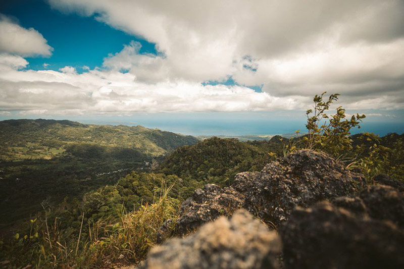
View from the top of Mayana Peak. Photo: Jackson Groves via Journey Era
Considered to be Bohol’s highest peak, Mayana Peak is located in the barangay of Mayana, in the town of Jagna. Mayana is also known as the “Little Baguio of Bohol,” due to its pertinent cooler weather. It also sits at 820km above sea level, making it a haven for beautiful flora and fauna.
You can take a bus from Tagbilaran to the town of Jagna, and from the Jagna public market, ride a jeep to the barangay of Mayana, or hire a habal-habal (motorcycle with driver) to take you to the area.
The trail is a bit tricky with no signs and marked trails, so be sure to have a guide with you. The ascent is also 45 minutes long, with slippery grounds and having only the branches and trunks of trees to hold on to.
Along the way, you will be treated to rice terraces, a centennial Narra tree, and plenty of beautiful scenery. Once you reach the top, the mountain ranges of 3 towns can be seen, offering a majestic view of Garcia, Duero, and the town of Candijay.
Rajah Sikatuna National Park
Trailhead of the Rajah Sikatuna National Park. Photo: boholtourismph.com
A birdwatcher’s paradise, the Rajah Sikatuna National Park is the widest remaining forest in Bohol. It was declared a National Park in 1987 and covers several towns in Bohol, which are Bilar, Valencia, Carmen, Batuan, Dimiao, Garcia Hernandez, and Sierra Bullones.
You can start the trail at Logarita in the town of Bilar, which is about 42km northeast of Tagbilaran City.
If you intend to do birdwatching, it is highly recommended that you bring a birdcall tape as the sound of the tapered bird will lure even the shyest of birds. Among other wildlife you can witness at the park include monkeys, tarsiers, bats, and it even has a butterfly sanctuary: talk about a trek for nature-lovers.
Bohol Sea of Clouds (Mt. Puntaas)
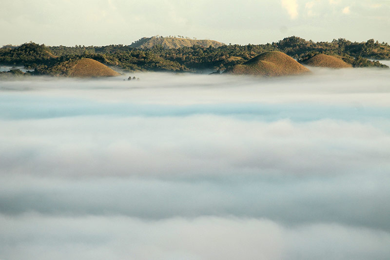
Hilltops jutting out of thick cloud cover as seen from Mt. Puntaas. Photo: eazytraveler.net
Known as the Bohol Sea of Clouds, Mt. Puntaas is a sight to behold. A curtain of clouds envelopes the valleys beneath, creating a surreal and ethereal view that can only be viewed early in the morning.
There are two towns in Bohol that serves as the starting point of the hike to the peak. You can go to the town of Danao, which is a 2 to 3-hour bus ride from Tagbilaran City, or you can also head to the town of Dagohoy. Whichever starting point you choose, you can head to the peak by hiring a habal-habal to take you to the starting point trail to Laguna Hills, where you will be asked to pay an entrance fee. From the foothills, Laguna Hills will only take about 10 minutes and after that, the Sea of Clouds is reachable within minutes.
The best time to witness the clouds is between the hours of 4:30 am to 6 am. Note that even if clouds can be seen all year-round, the weather still plays a big factor in their formation so advanced planning and some luck is still involved.
Bohol’s beauty doesn’t start and end with its pristine blue waters, or the majestic Chocolate Hills. With plenty of beauty even from the top, Bohol’s natural wonders are full of awe-inspiring sites and moments.
Feature photos: Sea of Clouds Bohol Facebook Page